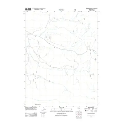
2012 Map of Harrison Pass
USGS Topo · Published 2012About this map
Harrison Pass serves as the central focal point of this high-elevation landscape in Elko County, where the drainages of the Ruby Mountains begin their descent into the surrounding basins. The map illustrates a network of seasonal and perennial watercourses, including Toyn Cr, Green Mountain Cr, and Corral Cr, which carve through the terrain beneath the shadow of Rattlesnake Mountain. Human presence in this area is defined by traditional ranching and recreational use, as seen at the Zaga Ranch, Corta Ranch, and the Pearl Creek Camp. The local infrastructure relies heavily on Forest Service routes like Natl Forest Develop Road 118 RD, which provides access to the higher ridges and water sources such as Pearl Cr and Brown Cr. This map documents a remote part of the Great Basin where the topography dictates both the travel routes and the location of isolated homesteads.
Find a feature on this map
18 named features on this map. Tap any name to fly to it.
Don’t see what you’re looking for? This feature index may not catch every label — zoom into the map to look around manually.
Map Details
Editions of this 2012 Harrison Pass Map
This is the sole edition of this map. No revisions or reprints were ever made.
Other maps of this area

1934 · Jiggs
USGS Topo · 1:125,000

1937 · Jiggs
USGS Topo · 1:125,000

1955 · Elko
USGS Topo · 1:250,000

1958 · Elko
USGS Topo · 1:250,000

1959 · Jiggs
USGS Topo · 1:62,500

1959 · Sherman Mtn
USGS Topo · 1:62,500

1962 · Elko
USGS Topo · 1:250,000

1965 · Elko
USGS Topo · 1:250,000

1968 · Franklin Lake SW
USGS Topo · 1:24,000
1968 · Ruby Lake NW
USGS Topo · 1:24,000