
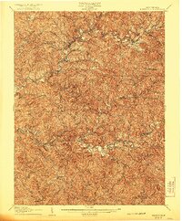
1907 Map of Harrisville
USGS Topo · Published 1907About this map
Harrisville serves as the focal point of this 1904 survey, situated where the terrain begins its winding descent toward the multiple forks of the Hughes River. The landscape is defined by a dense network of runs and creeks, illustrating a classic Appalachian drainage pattern that dictated early settlement and industry. Transportation in the early twentieth century relied heavily on the Baltimore and Ohio RR, which cuts through the northern portion of the map near Cairo and Cornwallis.
Find a feature on this map
80 named features on this map. Tap any name to fly to it.
Don’t see what you’re looking for? This feature index may not catch every label — zoom into the map to look around manually.
Map Details
Editions of this 1907 Harrisville Map
2 editions found
Other maps of this area

1893 · Sutton
USGS Topo · 1:125,000

1904 · Marietta
USGS Topo · 1:62,500

1905 · West Union
USGS Topo · 1:62,500

1906 · Saint Marys
USGS Topo · 1:62,500

1906 · Holbrook
USGS Topo · 1:62,500

1906 · Glenville
USGS Topo · 1:62,500

1906 · Elizabeth
USGS Topo · 1:62,500

1907 · Arnoldsburg
USGS Topo · 1:62,500

1907 · Spencer
USGS Topo · 1:62,500

1924 · St Marys
USGS Topo · 1:62,500