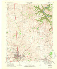
1967 Map of Harrodsburg
USGS Topo · Published 1970About this map
Harrodsburg sits at the heart of this survey, serving as a hub for the rolling landscape of Mercer County. The map illustrates the transition from the densely settled town center to the surrounding agricultural community, where legacy farms are linked by a dense network of named lanes like Bonta Lane and Chinn Lane. Local history is preserved in the numerous country churches and burial grounds, including New Providence Ch and the historic Spring Hill Cem.
Find a feature on this map
68 named features on this map. Tap any name to fly to it.
Don’t see what you’re looking for? This feature index may not catch every label — zoom into the map to look around manually.
Map Details
Editions of this 1967 Harrodsburg Map
3 editions found
Other maps of this area

1905 · Harrodsburg
USGS Topo · 1:125,000

1950 · Bryantsville
USGS Topo · 1:24,000

1952 · Perryville
USGS Topo · 1:24,000

1952 · Keene
USGS Topo · 1:24,000

1952 · Danville
USGS Topo · 1:24,000

1952 · Harrodsburg
USGS Topo · 1:24,000

1952 · Cornishville
USGS Topo · 1:24,000

1952 · Bryantsville
USGS Topo · 1:24,000

1952 · Salvisa
USGS Topo · 1:24,000

1952 · Mc Brayer
USGS Topo · 1:24,000