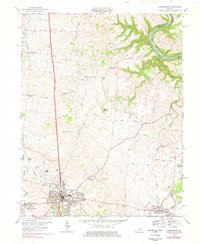
1967 Map of Harrodsburg
USGS Topo · Published 1978About this map
Harrodsburg serves as the focal point of this 1960s Kentucky landscape, where the dense street grid gives way to a network of rural lanes and established farmsteads. The terrain is deeply influenced by the winding course of the Kentucky River along the northeastern boundary, and the Salt River to the west, creating a corridor of limestone ridges and fertile bottoms. Outside the central town, the map documents small communities like Stringtown and McAfee, each anchored by local landmarks such as the New Providence Ch and the McAfee Sch.
Find a feature on this map
58 named features on this map. Tap any name to fly to it.
Don’t see what you’re looking for? This feature index may not catch every label — zoom into the map to look around manually.
Map Details
Editions of this 1967 Harrodsburg Map
3 editions found
Other maps of this area

1905 · Harrodsburg
USGS Topo · 1:125,000

1950 · Bryantsville
USGS Topo · 1:24,000

1952 · Perryville
USGS Topo · 1:24,000

1952 · Keene
USGS Topo · 1:24,000

1952 · Danville
USGS Topo · 1:24,000

1952 · Harrodsburg
USGS Topo · 1:24,000

1952 · Cornishville
USGS Topo · 1:24,000

1952 · Bryantsville
USGS Topo · 1:24,000

1952 · Salvisa
USGS Topo · 1:24,000

1952 · Mc Brayer
USGS Topo · 1:24,000