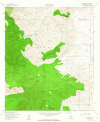
1958 Map of Harshaw
USGS Topo · Published 1963About this map
Mining operations and remote ranching outposts define this 1958 survey of the Patagonia Mountains south of Patagonia. The landscape is intensely marked by dozens of claims and shafts, ranging from the Worlds Fair Mine and Humboldt Mine in the north to the Kansas Mine and Maine Mine near the southern border. The settlement at Washington Camp and the nearby Duquesne Sch serve as the primary hubs for this high-altitude industry.
Find a feature on this map
66 named features on this map. Tap any name to fly to it.
Don’t see what you’re looking for? This feature index may not catch every label — zoom into the map to look around manually.
Map Details
Editions of this 1958 Harshaw Map
3 editions found
Other maps of this area

1904 · Patagonia
USGS Topo · 1:125,000

1905 · Patagonia
USGS Topo · 1:125,000

1905 · Nogales
USGS Topo · 1:125,000

1922 · Agus Caliente
USGS Topo · 1:62,500

1932 · Lochiel
USGS Topo · 1:62,500

1932 · Elgin
USGS Topo · 1:62,500

1933 · Calabasas
USGS Topo · 1:62,500

1940 · Elgin
USGS Topo · 1:62,500

1947 · Elgin
USGS Topo · 1:62,500

1948 · Canelo Pass
USGS Topo · 1:24,000