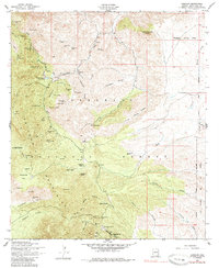
1958 Map of Harshaw
USGS Topo · Published 1985About this map
Washington Camp and the settlement of Harshaw anchor this mid-century look at a landscape defined by intensive silver and lead extraction. Situated within the Patagonia Mountains, the area is densely marked with claims that drove the local economy, from the Worlds Fair Mine in the north to the Maine Mine and New York Mine near the southern border. The transition from industrial mining to ranching is evident in family-named properties such as Shaffer Ranch and the Flying R Ranch, while local infrastructure is recorded at the Duquesne Sch and the Trench Camp water tank. Topographical landmarks like Saddle Mountain and American Peak rise above a network of drainages including Alum Gulch and Harshaw Creek. A single Grave noted near the Mowry Mine serves as a quiet reminder of the individual lives tied to these mountain camps during their period of operation.
Find a feature on this map
65 named features on this map. Tap any name to fly to it.
Don’t see what you’re looking for? This feature index may not catch every label — zoom into the map to look around manually.
Map Details
Editions of this 1958 Harshaw Map
3 editions found
Other maps of this area

1904 · Patagonia
USGS Topo · 1:125,000

1905 · Patagonia
USGS Topo · 1:125,000

1905 · Nogales
USGS Topo · 1:125,000

1922 · Agus Caliente
USGS Topo · 1:62,500

1932 · Lochiel
USGS Topo · 1:62,500

1932 · Elgin
USGS Topo · 1:62,500

1933 · Calabasas
USGS Topo · 1:62,500

1940 · Elgin
USGS Topo · 1:62,500

1947 · Elgin
USGS Topo · 1:62,500

1948 · Canelo Pass
USGS Topo · 1:24,000