
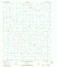
1963 Map of Hart SW
USGS Topo · Published 1965About this map
North Fork Running Water Draw and Running Water Draw carve winding ephemeral paths through the Llano Estacado on the High Plains of the Texas Panhandle. In the early 1960s, this landscape was defined by the transition from ranching to an intensive groundwater-based agricultural economy, shown here through an extensive grid of irrigation wells across the county line between Castro Co and Lamb Co. The presence of the Thompson Gin in the southern portion of the map indicates the local importance of cotton processing during this era. Scattered cattle infrastructure, such as the Corral in the west, persists alongside modern energy developments like the subterranean Pipeline. Numerous depression ponds, or playas, dot the surface, reflecting the unique hydrology of a region where every drop of water was vital to the emerging West Texas farm belt.
Find a feature on this map
7 named features on this map. Tap any name to fly to it.
Don’t see what you’re looking for? This feature index may not catch every label — zoom into the map to look around manually.
Map Details
Editions of this 1963 Hart SW Map
2 editions found
Other maps of this area

1954 · Clovis
USGS Topo · 1:250,000

1958 · Clovis
USGS Topo · 1:250,000

1962 · Dodd NE
USGS Topo · 1:24,000

1962 · Springlake
USGS Topo · 1:24,000

1963 · Hart NW
USGS Topo · 1:24,000

1963 · Olton
USGS Topo · 1:24,000

1963 · Dodd SE
USGS Topo · 1:24,000

1965 · Hart
USGS Topo · 1:24,000

1965 · Hilburn
USGS Topo · 1:24,000
1968 · Olton NE
USGS Topo · 1:24,000