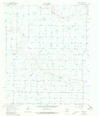
1963 Map of Hart SW
USGS Topo · Published 1981About this map
Agricultural development and hydrological features define this High Plains landscape along the boundary of Castro and Lamb Counties. The map illustrates a region heavily reliant on water management, dominated by the winding course of Running Water Draw and its North Fork. Small-scale industrial and ranching operations are visible, such as the Thompson Gin and a large Feedlot, which indicate the area's economic focus on cotton processing and livestock. Numerous water wells and scattered depressions are mapped throughout the terrain, providing a look at the irrigation infrastructure that transformed this part of the Texas Panhandle. A solitary Corral and a Pit further emphasize the land use patterns typical of the 1960s prior to the expansion of more modern industrial farming techniques.
Find a feature on this map
7 named features on this map. Tap any name to fly to it.
Don’t see what you’re looking for? This feature index may not catch every label — zoom into the map to look around manually.
Map Details
Editions of this 1963 Hart SW Map
2 editions found
Other maps of this area

1954 · Clovis
USGS Topo · 1:250,000

1958 · Clovis
USGS Topo · 1:250,000

1962 · Dodd NE
USGS Topo · 1:24,000

1962 · Springlake
USGS Topo · 1:24,000

1963 · Hart NW
USGS Topo · 1:24,000

1963 · Olton
USGS Topo · 1:24,000

1963 · Dodd SE
USGS Topo · 1:24,000

1963 · Hart SW
USGS Topo · 1:24,000

1965 · Hart
USGS Topo · 1:24,000

1965 · Hilburn
USGS Topo · 1:24,000