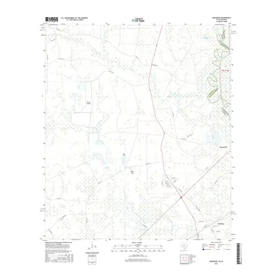
2016 Map of Hartburg
USGS Topo · Published 2016About this map
The Sabine River forms a complex, winding boundary between Texas and Louisiana on this 2016 survey, defining the eastern edge of Newton County. The landscape is characterized by its low-lying, water-logged terrain, where named features such as Blacks Prairie, Bull Cove, and Maple Gap indicate slight variations in elevation and vegetation within the marshy bottomlands. Water is the dominant force here, with Adams Bayou and Little Cypress Cr feeding into the intricate wetland systems of Nips Marsh and Negro Marsh. In the southern portion of the sheet, the community of Hartburg is situated near the junction of several local routes, including Stephens Cutoff and Co RD 4181. To the north, the settlement of Deweyville sits just west of the river's main channel, while Owens Lake and Black Marsh Slough mark the shifting course of the waterway over time.
Find a feature on this map
46 named features on this map. Tap any name to fly to it.
Don’t see what you’re looking for? This feature index may not catch every label — zoom into the map to look around manually.
Map Details
Editions of this 2016 Hartburg Map
This is the sole edition of this map. No revisions or reprints were ever made.
Other maps of this area

1926 · Texla
USGS Topo · 1:24,000

1926 · Mauriceville
USGS Topo · 1:24,000

1932 · Orange
USGS Topo · 1:62,500

1943 · Mauriceville
USGS Topo · 1:24,000

1943 · Texla
USGS Topo · 1:24,000

1947 · Starks
USGS Topo · 1:31,680

1947 · Toomey
USGS Topo · 1:31,680

1947 · Carter Creek
USGS Topo · 1:31,680

1952 · Lake Charles
USGS Topo · 1:250,000
1954 · Toomey
USGS Topo · 1:31,680