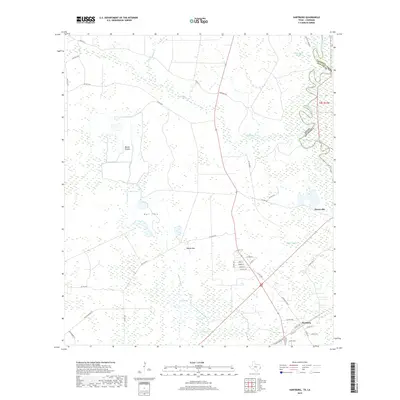
2019 Map of Hartburg
USGS Topo · Published 2019About this map
Hartburg and Deweyville anchor the eastern edge of Newton County, Texas, just across the state line from Calcasieu Parish. The landscape is defined by the winding course of the Sabine River and a dense network of water features including Little Cypress Cr, Black Marsh Slough, and the extensive Negro Marsh. This 2019 survey illustrates the low-lying coastal plain environment where distinct terrain features like Blacks Prairie and Bull Cove interrupt the wetlands. Local road networks, such as Sheppard Rd and Old Hwy 87, connect these small communities through the surrounding bayous. The hydrology of the region is notably intricate, with Adams Bayou and Owens Lake marking the transition toward the river valley. The proximity of the Texas-Louisiana border highlights the historical and geographic importance of the river as both a boundary and a corridor for the region's development.
Find a feature on this map
47 named features on this map. Tap any name to fly to it.
Don’t see what you’re looking for? This feature index may not catch every label — zoom into the map to look around manually.
Map Details
Editions of this 2019 Hartburg Map
This is the sole edition of this map. No revisions or reprints were ever made.
Other maps of this area

1926 · Texla
USGS Topo · 1:24,000

1926 · Mauriceville
USGS Topo · 1:24,000

1932 · Orange
USGS Topo · 1:62,500

1943 · Mauriceville
USGS Topo · 1:24,000

1943 · Texla
USGS Topo · 1:24,000

1947 · Starks
USGS Topo · 1:31,680

1947 · Toomey
USGS Topo · 1:31,680

1947 · Carter Creek
USGS Topo · 1:31,680

1952 · Lake Charles
USGS Topo · 1:250,000
1954 · Toomey
USGS Topo · 1:31,680