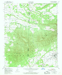
1947 Map of Hartford
USGS Topo · Published 1969About this map
Hartford and West Hartford anchor the southeastern corner of this 1940s survey, straddling the border between Arkansas and Oklahoma. The landscape is dominated by the massive profile of Sugar Loaf Mountain, which stretches across the center of the sheet alongside Oklahoma Peak and Midland Peak. These peaks divide the drainage of Kully Ch Aha Creek to the west from the various branches of the Jim Fork to the east. The presence of numerous Coal labels near the town sites indicates the region's industrial ties to mining during this era. Scattered rural settlements such as Slaytonville, Riddle, and Nall are shown connected by a network of winding roads, many following the natural contours of Scott Ridge and the valleys of Riddle Creek and Sugar Loaf Creek. Small cemeteries and family plots are marked throughout the hills, providing valuable data for genealogical research into the families who occupied these borderlands.
Find a feature on this map
26 named features on this map. Tap any name to fly to it.
Don’t see what you’re looking for? This feature index may not catch every label — zoom into the map to look around manually.
Map Details
Editions of this 1947 Hartford Map
3 editions found
Other maps of this area

1887 · Poteau Mountain #2
USGS Topo · 1:62,500

1887 · Greenwood
USGS Topo · 1:62,500

1890 · Fort Smith
USGS Topo · 1:125,000

1890 · Poteau Mountain
USGS Topo · 1:125,000

1899 · Poteau Mountain
USGS Topo · 1:125,000

1900 · Sallisaw
USGS Topo · 1:125,000

1900 · Winding Stair
USGS Topo · 1:125,000

1909 · Winding Stair
USGS Topo · 1:125,000

1911 · Sallisaw
USGS Topo · 1:125,000

1943 · Fort Smith
USGS Topo · 1:125,000