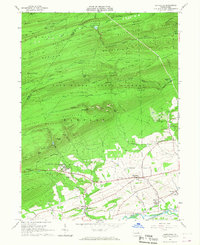
1965 Map of Hartleton
USGS Topo · Published 1967About this map
Laurelton State Village anchors the southern portion of this mid-1960s survey, representing a significant institutional presence in the region's mid-century landscape. To the north, the geography is defined by the steep, parallel ridges of Bald Eagle State Forest, where features like Bake Oven Mountain and Seven Notch Mountain rise above the deep cut of the Fourteenmile Narrows. Local transit and leisure are reflected in the presence of Raymond B Winter State Park and an Old Railroad Grade that traces the valley floors.
Find a feature on this map
72 named features on this map. Tap any name to fly to it.
Don’t see what you’re looking for? This feature index may not catch every label — zoom into the map to look around manually.
Map Details
Editions of this 1965 Hartleton Map
2 editions found
Other maps of this area

1921 · Williamsport
USGS Topo · 1:48,000

1921 · Lock Haven
USGS Topo · 1:62,500

1923 · Lock Haven
USGS Topo · 1:62,500

1923 · Williamsport
USGS Topo · 1:62,500

1937 · Millheim
USGS Topo · 1:48,000

1938 · Mifflinburg
USGS Topo · 1:48,000

1941 · Millheim
USGS Topo · 1:62,500

1943 · Mifflinburg
USGS Topo · 1:62,500

1944 · Williamsport
USGS Topo · 1:62,500

1944 · Lock Haven
USGS Topo · 1:62,500