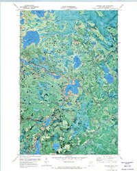
1971 Map of Hartley Lake
USGS Topo · Published 1973About this map
George Washington State Forest encompasses much of this 1971 orthophotomap, showing a complex glacial landscape defined by its intricate water network. The terrain is characterized by a dense concentration of kettle lakes and drainage systems, including the West Fork Prairie River which winds through the center of the sheet to meet the Prairie River. This map is particularly interesting for its visual record of the land cover, where timber stands and wetlands are visible around major water bodies like Hartley Lake, Round Lake, and Wolf Lake. A Winter Trail in the northern section and the Forest Boundary in the south indicate the region's managed nature and seasonal accessibility. Notable for genealogists and local historians are the numerous smaller named lakes, such as Stumpie Lake, Scooty Lake, and Christmas Lake, which serve as permanent landmarks in this remote northern Minnesota territory.
Find a feature on this map
23 named features on this map. Tap any name to fly to it.
Don’t see what you’re looking for? This feature index may not catch every label — zoom into the map to look around manually.
Map Details
Editions of this 1971 Hartley Lake Map
This is the sole edition of this map. No revisions or reprints were ever made.
Other maps of this area

1919 · Release
USGS Topo · 1:62,500

1920 · Trout Lake
USGS Topo · 1:62,500

1943 · Release
USGS Topo · 1:62,500

1952 · Nashwauk
USGS Topo · 1:24,000

1954 · Hibbing
USGS Topo · 1:250,000

1957 · Hibbing
USGS Topo · 1:250,000

1958 · Hibbing
USGS Topo · 1:250,000

1964 · Hibbing
USGS Topo · 1:250,000

1964 · Sherry Lake
USGS Topo · 1:24,000
1964 · O'Leary Lake
USGS Topo · 1:24,000