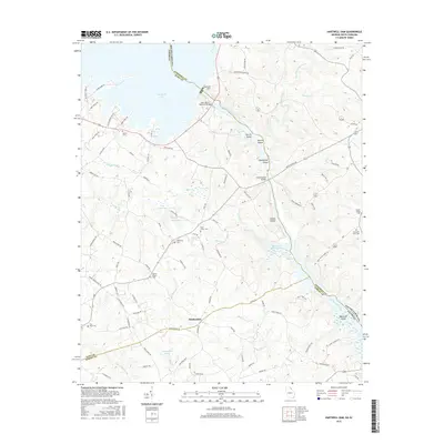
2017 Map of Hartwell Dam
USGS Topo · Published 2017About this map
Montevideo sits at the heart of this landscape where the Savannah River serves as the dividing line between Georgia and South Carolina. This modern survey illustrates the complex water management systems of the region, anchored by the Hartwell Dam and the massive reservoirs it created, including Hartwell Lake and Richard B Russell Lake. Numerous small islands like Derritt Island and Greens Island emerge from these impounded waters, marking the high points of a flooded river valley.
Find a feature on this map
102 named features on this map. Tap any name to fly to it.
Don’t see what you’re looking for? This feature index may not catch every label — zoom into the map to look around manually.
Map Details
Editions of this 2017 Hartwell Dam Map
This is the sole edition of this map. No revisions or reprints were ever made.
Other maps of this area

1893 · Elberton
USGS Topo · 1:125,000

1954 · Greenville
USGS Topo · 1:250,000

1958 · Greenville
USGS Topo · 1:250,000

1958 · Elberton
USGS Topo · 1:62,500

1959 · Hartwell Dam
USGS Topo · 1:24,000

1959 · Hartwell NE
USGS Topo · 1:24,000

1959 · Hartwell
USGS Topo · 1:24,000
1960 · Reed Creek
USGS Topo · 1:24,000

1964 · Iva
USGS Topo · 1:24,000

1964 · Lowndesville
USGS Topo · 1:24,000