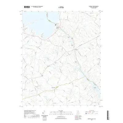
2020 Map of Hartwell Dam
USGS Topo · Published 2020About this map
Montevideo sits at the southern reach of this landscape, positioned where the border of Hart and Elbert Counties meets the winding waters of the Savannah River basin. The geography is dominated by the massive impoundments of Hartwell Lake and Richard B Russell Lake, which have reshaped the historic river valley into a complex network of inlets and islands. Significant landforms like Derritt Island and Greens Island remain above the waterline, while the Hartwell Dam stands as a major structural landmark near the Georgia-South Carolina state line.
Find a feature on this map
101 named features on this map. Tap any name to fly to it.
Don’t see what you’re looking for? This feature index may not catch every label — zoom into the map to look around manually.
Map Details
Editions of this 2020 Hartwell Dam Map
This is the sole edition of this map. No revisions or reprints were ever made.
Other maps of this area

1893 · Elberton
USGS Topo · 1:125,000

1954 · Greenville
USGS Topo · 1:250,000

1958 · Greenville
USGS Topo · 1:250,000

1958 · Elberton
USGS Topo · 1:62,500

1959 · Hartwell Dam
USGS Topo · 1:24,000

1959 · Hartwell NE
USGS Topo · 1:24,000

1959 · Hartwell
USGS Topo · 1:24,000
1960 · Reed Creek
USGS Topo · 1:24,000

1964 · Iva
USGS Topo · 1:24,000

1964 · Lowndesville
USGS Topo · 1:24,000