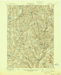
1912 Map of Hartwick
USGS Topo · Published 1944About this map
Southern New York Electric Railway tracks cut through the eastern hills of Otsego County, following the valley floors past South Hartwick and Mt. Vision. This early 20th-century landscape is defined by a dense network of upland farms and small valley settlements connected by winding roads that predate the modern highway system. The terrain is deeply etched by the Butternut Creek and Otego Creek drainages, which historically powered the local mills and influenced the placement of towns like Garrattsville and Laurens. From the northern reaches of Burlington Flats to the southern waters of Wilber Lake, the map captures the transition from isolated agricultural communities to a region increasingly linked by electric rail. Small natural features like Cranberry Bog and Hurd Lake dot the ridges, providing a detailed view of the rural Otsego landscape before significant mid-century changes.
Find a feature on this map
44 named features on this map. Tap any name to fly to it.
Don’t see what you’re looking for? This feature index may not catch every label — zoom into the map to look around manually.
Map Details
Editions of this 1912 Hartwick Map
4 editions found

Other maps of this area

1903 · Richfield Springs
USGS Topo · 1:62,500

1907 · Winfield
USGS Topo · 1:62,500

1907 · Sangerfield
USGS Topo · 1:62,500

1907 · Cooperstown
USGS Topo · 1:62,500

1909 · Cooperstown
USGS Topo · 1:62,500

1909 · Delhi
USGS Topo · 1:62,500

1910 · Hartwick
USGS Topo · 1:62,500

1910 · New Berlin
USGS Topo · 1:62,500

1911 · Delhi
USGS Topo · 1:62,500

1912 · New Berlin
USGS Topo · 1:62,500