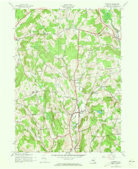
1943 Map of Hartwick
USGS Topo · Published 1973About this map
Hartwick and the surrounding rural townships of Otsego County are captured here during the Second World War, showing a landscape defined by small valley settlements and high ridgeline farms. The area’s water network, including Otego Creek and Butternut Creek, dictated the early placement of hamlets such as Oaksville and Burlington. Local life in the mid-1940s is traced through a dense network of district schoolhouses like School No 6 and School No 17, alongside family and community landmarks like Peck Cem and Maple Cem.
Find a feature on this map
43 named features on this map. Tap any name to fly to it.
Don’t see what you’re looking for? This feature index may not catch every label — zoom into the map to look around manually.
Map Details
Editions of this 1943 Hartwick Map
4 editions found
Other maps of this area

1903 · Richfield Springs
USGS Topo · 1:62,500

1907 · Winfield
USGS Topo · 1:62,500

1907 · Cooperstown
USGS Topo · 1:62,500

1909 · Cooperstown
USGS Topo · 1:62,500

1910 · Hartwick
USGS Topo · 1:62,500

1912 · Hartwick
USGS Topo · 1:62,500

1943 · Schuyler Lake
USGS Topo · 1:24,000

1943 · Mt Vision
USGS Topo · 1:24,000

1943 · Milford
USGS Topo · 1:24,000

1943 · Richfield Springs
USGS Topo · 1:24,000