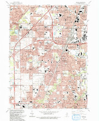
1993 Map of Harvey
USGS Topo · Published 1993About this map
Cook County south of Chicago is defined by dense residential growth and a complex network of industrial transport during the early 1990s. The landscape is a corridor of established suburban communities including Harvey, Homewood, and Chicago Heights, where residential grids are partitioned by major transit arteries like the Tri-State Tollway and the Illinois Central Railroad. The map reveals a high concentration of civic and religious infrastructure, notably the cluster of academic institutions such as Bloom Community College, Tolentine College, and numerous parochial schools like St Damian Sch and St Anne Sch.
Find a feature on this map
94 named features on this map. Tap any name to fly to it.
Don’t see what you’re looking for? This feature index may not catch every label — zoom into the map to look around manually.
Map Details
Editions of this 1993 Harvey Map
This is the sole edition of this map. No revisions or reprints were ever made.
Other maps of this area

1890 · Des Plaines
USGS Topo · 1:62,500

1892 · Calumet
USGS Topo · 1:62,500

1893 · Calumet
USGS Topo · 1:62,500

1894 · Des Plaines
USGS Topo · 1:62,500

1900 · Des Plaines
USGS Topo · 1:62,500

1900 · Calumet
USGS Topo · 1:62,500

1901 · Calumet
USGS Topo · 1:62,500

1901 · Des Plaines
USGS Topo · 1:62,500

1928 · Palos Park
USGS Topo · 1:24,000

1929 · Tinley Park
USGS Topo · 1:24,000