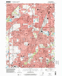
1998 Map of Harvey
USGS Topo · Published 2002About this map
Harvey and its neighboring Cook County suburbs appear here during a period of intense post-war residential expansion, bounded by industrial corridors and the Tri-State Tollway. The landscape is a dense grid of mid-century growth, where older village cores like Homewood and Flossmoor are increasingly joined by newer developments like Country Club Hills and Olympia Fields. Despite the urban sprawl, large tracts of the Forest Preserve system, such as Midlothian Meadows, maintain green buffers between the rail lines and residential streets.
Find a feature on this map
95 named features on this map. Tap any name to fly to it.
Don’t see what you’re looking for? This feature index may not catch every label — zoom into the map to look around manually.
Map Details
Editions of this 1998 Harvey Map
This is the sole edition of this map. No revisions or reprints were ever made.
Other maps of this area

1890 · Des Plaines
USGS Topo · 1:62,500

1892 · Calumet
USGS Topo · 1:62,500

1893 · Calumet
USGS Topo · 1:62,500

1894 · Des Plaines
USGS Topo · 1:62,500

1900 · Des Plaines
USGS Topo · 1:62,500

1900 · Calumet
USGS Topo · 1:62,500

1901 · Calumet
USGS Topo · 1:62,500

1901 · Des Plaines
USGS Topo · 1:62,500

1928 · Palos Park
USGS Topo · 1:24,000

1929 · Tinley Park
USGS Topo · 1:24,000