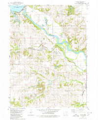
1980 Map of Harvey
USGS Topo · Published 1980About this map
Des Moines River meanders through this landscape, dividing Lake Prairie from the surrounding township as it flows toward the community of Harvey. The map details a transition between protected natural areas and industrial footprints, shown by the Pella State Game Management Area adjacent to extensive Strip Mined Areas. The regional transport network is anchored by the Norfolk and Western Burlington Northern rail lines and an Old Railroad Grade that traces the historic movement of goods through small settlements like Durham and Tracy. For the family historian, the map identifies several distinct burial grounds, including Eureka Cem and Porter Grove Cem, which remain as fixed points in an area otherwise altered by mining and the waters of Lake Red Rock. These features together reveal a mid-continent landscape balancing conservation, extraction, and rural residency.
Find a feature on this map
32 named features on this map. Tap any name to fly to it.
Don’t see what you’re looking for? This feature index may not catch every label — zoom into the map to look around manually.
Map Details
Editions of this 1980 Harvey Map
This is the sole edition of this map. No revisions or reprints were ever made.
Other maps of this area

1909 · Knoxville
USGS Topo · 1:62,500

1910 · Pella
USGS Topo · 1:62,500

1912 · Knoxville
USGS Topo · 1:62,500

1912 · Pella
USGS Topo · 1:62,500

1924 · Melcher
USGS Topo · 1:62,500

1929 · Albia
USGS Topo · 1:62,500

1954 · Des Moines
USGS Topo · 1:250,000

1956 · Des Moines
USGS Topo · 1:250,000

1957 · Des Moines
USGS Topo · 1:250,000
1965 · Otley
USGS Topo · 1:24,000