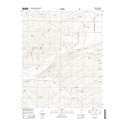
2014 Map of Harvey
USGS Topo · Published 2014About this map
The Fourche Lafave River carves a serpentine path through this 2014 survey of Scott County, providing the primary drainage for a landscape defined by prominent ridges like Bogus Ridge and Hurricane Ridge. The small settlements of Harvey and Forester serve as quiet anchors in the Ouachita National Forest, where the terrain transitions from the low-lying Beaver Slough to the height of Abbot Mtn. Local family history is preserved at the Harvey Cem, Sanders Cem, and Big Cedar Cem, each positioned near early road networks like State Hwy 28. A notable landmark for fire spotting and navigation, the Abbot Lookout Tower stands as a point of interest for researchers of forest management history. The map also traces numerous creek systems, including Big Cedar Cr and Brush Cr, which shaped the early development and topography of this river valley.
Find a feature on this map
76 named features on this map. Tap any name to fly to it.
Don’t see what you’re looking for? This feature index may not catch every label — zoom into the map to look around manually.
Map Details
Editions of this 2014 Harvey Map
This is the sole edition of this map. No revisions or reprints were ever made.
Other maps of this area

1887 · Mount Ida #2
USGS Topo · 1:62,500

1890 · Mount Ida
USGS Topo · 1:125,000

1955 · Little Rock
USGS Topo · 1:250,000

1956 · Little Rock
USGS Topo · 1:250,000

1959 · Oden
USGS Topo · 1:62,500

1959 · Mount Ida
USGS Topo · 1:62,500

1960 · Little Rock
USGS Topo · 1:250,000

1960 · Gravelly
USGS Topo · 1:62,500
1960 · Parks
USGS Topo · 1:62,500

1964 · Little Rock
USGS Topo · 1:250,000