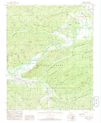
1985 Map of Harvey
USGS Topo · Published 1986About this map
The Fourche La Fave River and its various tributaries define the landscape of this mid-1980s survey of Scott County. Small settlements such as Harvey and Cedar Creek are found alongside the river's winding path, while the southern half of the map is dominated by the Ouachita National Forest and the Muddy Creek State Wildlife Management Area. The terrain is characterized by numerous ridges and hollows, including the family-named John Sanders Ridge and the descriptively named Stillhouse Hollow. Evidence of local industry and infrastructure is present through a Shale Pit near Harvey and a Gravel Pit near Forester, along with a rural Cem located near the junction of several forest roads. The map illustrates a region where timber management and recreation coexist with small, dispersed communities along the river valley floor.
Find a feature on this map
50 named features on this map. Tap any name to fly to it.
Don’t see what you’re looking for? This feature index may not catch every label — zoom into the map to look around manually.
Map Details
Editions of this 1985 Harvey Map
This is the sole edition of this map. No revisions or reprints were ever made.
Other maps of this area

1887 · Mount Ida #2
USGS Topo · 1:62,500

1890 · Mount Ida
USGS Topo · 1:125,000

1955 · Little Rock
USGS Topo · 1:250,000

1956 · Little Rock
USGS Topo · 1:250,000

1959 · Oden
USGS Topo · 1:62,500

1959 · Mount Ida
USGS Topo · 1:62,500

1960 · Little Rock
USGS Topo · 1:250,000

1960 · Gravelly
USGS Topo · 1:62,500
1960 · Parks
USGS Topo · 1:62,500

1964 · Little Rock
USGS Topo · 1:250,000