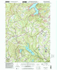
1999 Map of Harveys Lake
USGS Topo · Published 2001About this map
Harveys Lake dominates the northeastern corner of this Luzerne County landscape, serving as a focal point for surrounding clusters of settlement like Shawanese, Idetown, and Laketon. The terrain transitions from the heights of North Mountain and Kocher Mtn in the west down toward the Harveys Creek and Pikes Creek drainages. By the late 1990s, the area shows a complex mix of protected natural spaces, including a section of the Lackawanna State Forest, alongside significant institutional and recreational footprints such as the State Correctional Institution - Dallas and several golf courses.
Find a feature on this map
43 named features on this map. Tap any name to fly to it.
Don’t see what you’re looking for? This feature index may not catch every label — zoom into the map to look around manually.
Map Details
Editions of this 1999 Harveys Lake Map
This is the sole edition of this map. No revisions or reprints were ever made.
Other maps of this area

1891 · Wilkesbarre
USGS Topo · 1:62,500

1891 · Harveys Lake
USGS Topo · 1:62,500

1893 · Harvey Lake
USGS Topo · 1:62,500

1893 · Pittston
USGS Topo · 1:62,500

1894 · Shickshinny
USGS Topo · 1:62,500

1894 · Wilkesbarre
USGS Topo · 1:62,500

1943 · Scranton
USGS Topo · 1:125,000

1946 · Nanticoke
USGS Topo · 1:31,680

1946 · Shickshinny
USGS Topo · 1:31,680

1946 · Kingston
USGS Topo · 1:24,000
Featured Places
- Dallas Township, PA
- Lehman Township, PA
- Harveys Lake, PA
- Hunlock Township, PA
- Pikes Creek, Lake Township