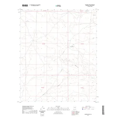
2023 Map of Hasperos Camp
USGS Topo · Published 2023About this map
Hasperos Canyon and its smaller counterpart, Little Hasperos Canyon, define the drainage patterns of this high-desert landscape in Lincoln County. Modern land use is primarily reflected in the network of water management features such as North Hasperos Tank and Parker Tank, which are essential for livestock and local wildlife in an arid environment. The map details a transition from the winding course of Gallo Arroyo in the northeast down toward the southern reaches near Lavade Draw. This 2023 edition documents the area's current road network, including Co Rd B001 and routes labeled Bogle, providing a clear record of the access points through these central New Mexico canyons and draws.
Find a feature on this map
16 named features on this map. Tap any name to fly to it.
Don’t see what you’re looking for? This feature index may not catch every label — zoom into the map to look around manually.
Map Details
Editions of this 2023 Hasperos Camp Map
This is the sole edition of this map. No revisions or reprints were ever made.
Other maps of this area

1954 · Fort Sumner
USGS Topo · 1:250,000

1955 · Roswell
USGS Topo · 1:250,000

1958 · Fort Sumner
USGS Topo · 1:250,000

1958 · Roswell
USGS Topo · 1:250,000

1962 · Roswell
USGS Topo · 1:250,000

1973 · Chupadero Mountain
USGS Topo · 1:24,000

1973 · Jicarilla Peak
USGS Topo · 1:24,000

1980 · Corona
USGS Topo · 1:100,000
1981 · Pedernal Arroyo
USGS Topo · 1:24,000
1981 · Pelon Hill
USGS Topo · 1:24,000