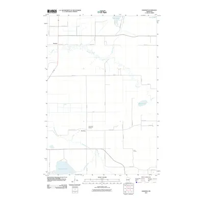
2010 Map of Hassman
USGS Topo · Published 2010About this map
The Rice River meanders sharply across the northern landscape of this Aitkin County quadrangle, defining the terrain between the settlements of Hassman and Rossburg. This 2010 survey shows a region deeply connected to its glacial waters, where Sisabagamah Lake and Fleming Lake anchor the southern and northern boundaries respectively. The transportation network is a mix of state routes and township roads like Spencer Cematary Rd and Dam Lake St, reflecting a rural structure that has evolved around natural watercourses like Fleming Brook and Rabbit Creek.
Find a feature on this map
37 named features on this map. Tap any name to fly to it.
Don’t see what you’re looking for? This feature index may not catch every label — zoom into the map to look around manually.
Map Details
Editions of this 2010 Hassman Map
This is the sole edition of this map. No revisions or reprints were ever made.
Other maps of this area

1914 · Aitkin
USGS Topo · 1:62,500

1915 · Aitkin
USGS Topo · 1:62,500

1916 · Wealthwood
USGS Topo · 1:62,500

1953 · Duluth
USGS Topo · 1:250,000

1958 · Duluth
USGS Topo · 1:250,000

1969 · Thor
USGS Topo · 1:24,000

1970 · Kimberly
USGS Topo · 1:24,000

1970 · Palisade
USGS Topo · 1:24,000
1973 · Waukenabo
USGS Topo · 1:24,000
1973 · Hassman
USGS Topo · 1:24,000