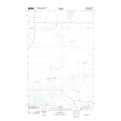
2013 Map of Hassman
USGS Topo · Published 2013About this map
The meandering Rice River carves a winding path through this central Minnesota landscape, defining the character of the wetlands and forests near the settlement of Hassman. This survey illustrates a rural corridor where transportation and local history converge, particularly at the crossroads of Rossburg. The area is marked by significant genealogical landmarks, including the Church of the Blessed Virgin Cem and Forest Cem, providing valuable touchpoints for family historians. A complex network of waterways, from Fleming Brook in the north to the large expanse of Sisabagama Lake in the southwest, suggests a terrain historically shaped by timber and early homesteading. Modern routes like MN-210 and Us-169 intersect here, overlaying a grid of township roads such as Spencer Cematary Rd and Dam Lake St.
Find a feature on this map
33 named features on this map. Tap any name to fly to it.
Don’t see what you’re looking for? This feature index may not catch every label — zoom into the map to look around manually.
Map Details
Editions of this 2013 Hassman Map
This is the sole edition of this map. No revisions or reprints were ever made.
Other maps of this area

1914 · Aitkin
USGS Topo · 1:62,500

1915 · Aitkin
USGS Topo · 1:62,500

1916 · Wealthwood
USGS Topo · 1:62,500

1953 · Duluth
USGS Topo · 1:250,000

1958 · Duluth
USGS Topo · 1:250,000

1969 · Thor
USGS Topo · 1:24,000

1970 · Kimberly
USGS Topo · 1:24,000

1970 · Palisade
USGS Topo · 1:24,000
1973 · Waukenabo
USGS Topo · 1:24,000
1973 · Hassman
USGS Topo · 1:24,000