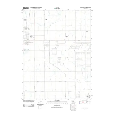
2011 Map of Hastings East
USGS Topo · Published 2011About this map
The West Fork Big Blue River and Big Sandy Creek define the agricultural landscape of this region east of Hastings. In the early 21st century, the area shows a clear transition from urban expansion to rural farmland, with residential and commercial developments like Kingswood Plaza and Good Samaritan Village bordering the city. The township grid is dotted with small, historically significant nodes such as Blaine, Halloran, and Muriel, while the community of Glenvil anchors the southeastern corner, complete with the Glenvil Post Office. Genealogists will find this 2011 survey particularly valuable for locating local burial grounds, including Parkview Cemetery, Mount Sinai Cemetery, and the more isolated Inland Cemetery. The map also illustrates the industrial and transit infrastructure of the era, with routes like S Technical Blvd and Coaltrain Rd serving the outlying sectors of the city.
Find a feature on this map
58 named features on this map. Tap any name to fly to it.
Don’t see what you’re looking for? This feature index may not catch every label — zoom into the map to look around manually.
Map Details
Editions of this 2011 Hastings East Map
This is the sole edition of this map. No revisions or reprints were ever made.
Other maps of this area

1898 · Superior
USGS Topo · 1:125,000

1898 · Grand Island
USGS Topo · 1:125,000

1955 · Grand Island
USGS Topo · 1:250,000

1957 · Grand Island
USGS Topo · 1:250,000

1958 · Grand Island
USGS Topo · 1:250,000

1969 · Hastings East
USGS Topo · 1:24,000

1969 · Fairfield NW
USGS Topo · 1:24,000
1969 · Trumbull
USGS Topo · 1:24,000
1969 · Hastings West
USGS Topo · 1:24,000
1969 · Hastings NW
USGS Topo · 1:24,000