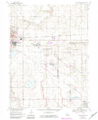
1983 Map of Hastings East
USGS Topo · Published 1984About this map
The eastern reaches of Hastings and the surrounding agricultural plains of Adams County are meticulously documented in this 1983 revision. The urban edge is defined by institutions such as Hastings College and the extensive Good Samaritan Village complex, while the rural landscape is partitioned by a dense network of transit, including the Burlington Northern and Union Pacific railroads. A significant portion of the southeastern territory is occupied by the Army National Guard Training Site, reflecting the region's long-standing military and governmental infrastructure.
Find a feature on this map
36 named features on this map. Tap any name to fly to it.
Don’t see what you’re looking for? This feature index may not catch every label — zoom into the map to look around manually.
Map Details
Editions of this 1983 Hastings East Map
This is the sole edition of this map. No revisions or reprints were ever made.
Other maps of this area

1898 · Superior
USGS Topo · 1:125,000

1898 · Grand Island
USGS Topo · 1:125,000

1955 · Grand Island
USGS Topo · 1:250,000

1957 · Grand Island
USGS Topo · 1:250,000

1958 · Grand Island
USGS Topo · 1:250,000

1969 · Hastings East
USGS Topo · 1:24,000

1969 · Fairfield NW
USGS Topo · 1:24,000
1969 · Trumbull
USGS Topo · 1:24,000
1969 · Hastings West
USGS Topo · 1:24,000
1969 · Hastings NW
USGS Topo · 1:24,000