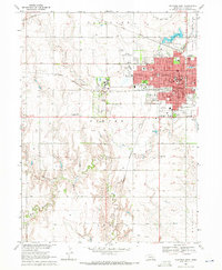
1969 Map of Hastings West
USGS Topo · Published 1971About this map
The western expansion of Hastings in the late 1960s is defined by a dense institutional and residential grid transitioning into the rolling drainage of the Big Blue River. This landscape is marked by the sprawling grounds of the Hastings State Hospital and the nearby settlement of Ingleside, alongside significant religious and educational landmarks such as the Crosier Monastery and St Michaels Sch. The map illustrates a city anchored by diverse infrastructure, including the Hastings Municipal Airport and the heavy rail corridors of the Union Pacific and Burlington Northern. Beyond the city limits, the terrain softens into the meandering paths of Pawnee Creek and Thirtytwo Mile Creek, where smaller rural fixtures like Wallace Sch and Immanuel Ch served the outlying townships of Denver and Ayr.
Find a feature on this map
54 named features on this map. Tap any name to fly to it.
Don’t see what you’re looking for? This feature index may not catch every label — zoom into the map to look around manually.
Map Details
Editions of this 1969 Hastings West Map
3 editions found
Other maps of this area

1894 · Kenesaw
USGS Topo · 1:62,500

1896 · Wood River
USGS Topo · 1:125,000

1897 · Red Cloud
USGS Topo · 1:125,000

1898 · Superior
USGS Topo · 1:125,000

1898 · Grand Island
USGS Topo · 1:125,000

1955 · Grand Island
USGS Topo · 1:250,000

1957 · Grand Island
USGS Topo · 1:250,000

1958 · Grand Island
USGS Topo · 1:250,000

1962 · Prosser
USGS Topo · 1:24,000

1969 · Hastings East
USGS Topo · 1:24,000
Featured Places
- Hastings, NE
- Ingleside, NE
- Bonnavilla and Eastgate Mobile Home Park, Hastings
- Countryside Parks, Hastings
- Adams County, NE