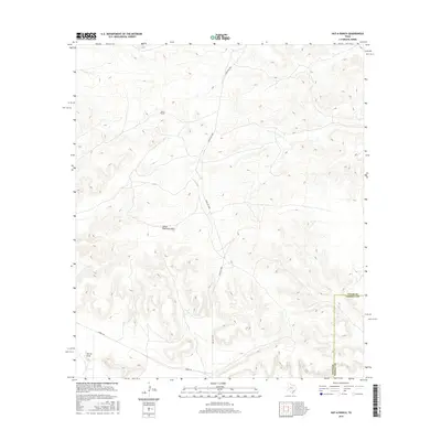
2016 Map of Hat-A Ranch
USGS Topo · Published 2016About this map
The Hat-A Ranch serves as a primary landmark in this remote section of West Texas, where the landscape is defined by the steep contouring of the Stockton Plateau. This 2016 survey highlights a geography carved by seasonal watercourses, notably Lower Fourmile Draw and Harral Draw, which dictate the local topography. Human infrastructure is limited to essential ranching corridors, with Ranch Rd 2886 providing north-south transit through the center of the quadrangle. Near the southern edge, the crossing of Harral Rd and the political boundary between Pecos and Terrell Counties illustrate how property and administrative lines were established relative to these drainage basins. The map offers a clear view of modern land management and road networks in an area where the terrain remains the dominant feature.
Find a feature on this map
6 named features on this map. Tap any name to fly to it.
Don’t see what you’re looking for? This feature index may not catch every label — zoom into the map to look around manually.
Map Details
Editions of this 2016 Hat-A Ranch Map
This is the sole edition of this map. No revisions or reprints were ever made.
Other maps of this area

1929 · Independence Draw Quadrangle
USGS Topo · 1:125,000

1954 · Fort Stockton
USGS Topo · 1:250,000

1958 · Fort Stockton
USGS Topo · 1:250,000
1969 · Smoky Mountain Ranch
USGS Topo · 1:24,000
1969 · Mitchell Draw
USGS Topo · 1:24,000
1969 · Seventeen Ranch
USGS Topo · 1:24,000

1969 · Hackberry Draw NE
USGS Topo · 1:24,000
1969 · Hackberry Draw SE
USGS Topo · 1:24,000
1969 · Hat-A Ranch
USGS Topo · 1:24,000
1969 · Indian Mesa SE
USGS Topo · 1:24,000