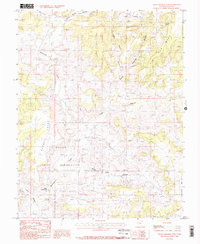
1985 Map of Hatch Trading Post
USGS Topo · Published 1985About this map
Hatch Trading Post serves as a lone commercial focal point in this high desert landscape of southeastern Utah during the mid-1980s. The terrain is defined by a complex system of drainages and mesas, where the Navajo Indian Reservation meets the rugged breaks of the San Juan County plateau. The map details a labyrinth of seasonal watercourses including Montezuma Creek and Cross Canyon, which cut deep paths through elevations like Tin Cup Mesa and Cajon Mesa. Smaller family-named landmarks such as Johnny Benal Canyon and Nancy Canyon suggest the enduring local presence of ranching and indigenous heritage in this arid region. Industrial activity is sparse, marked only by an occasional Prospect or Gravel Pit, while the vastness of Bug Park and Alkali Point illustrates the expansive, open character of the Four Corners backcountry before modern development intensified.
Find a feature on this map
17 named features on this map. Tap any name to fly to it.
Don’t see what you’re looking for? This feature index may not catch every label — zoom into the map to look around manually.
Map Details
Editions of this 1985 Hatch Trading Post Map
2 editions found
Other maps of this area

1886 · Abajo
USGS Topo · 1:250,000

1892 · Abajo
USGS Topo · 1:250,000

1893 · Abajo
USGS Topo · 1:250,000

1955 · Verdure 3 SE
USGS Topo · 1:24,000

1955 · Verdure 4 SW
USGS Topo · 1:24,000

1956 · Cortez
USGS Topo · 1:250,000

1957 · Aneth 1 NE
USGS Topo · 1:24,000

1957 · Aneth 1 NW
USGS Topo · 1:24,000

1957 · Monument Canyon
USGS Topo · 1:62,500

1957 · Blanding
USGS Topo · 1:62,500