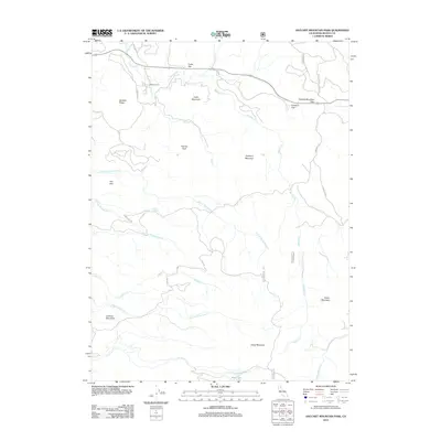
2012 Map of Hatchet Mountain Pass
USGS Topo · Published 2012About this map
Hatchet Mountain Pass serves as a central geographic anchor for this 2012 survey, marking a high point between the drainages of Hatchet Cr and Green Burney Cr. This portion of Shasta County is characterized by significant topographic relief, where prominent summits like Fauries Peak, Snow Mountain, and Fuller Mountain rise above the complex network of watercourses. The drainage patterns are particularly intricate, with the N Fork Montgomery Cr and S Fork Montgomery Cr carving through the western slopes.
Find a feature on this map
34 named features on this map. Tap any name to fly to it.
Don’t see what you’re looking for? This feature index may not catch every label — zoom into the map to look around manually.
Map Details
Editions of this 2012 Hatchet Mountain Pass Map
This is the sole edition of this map. No revisions or reprints were ever made.
Other maps of this area

1886 · Lassen Peak
USGS Topo · 1:250,000

1892 · Lassen Peak
USGS Topo · 1:250,000

1894 · Lassen Peak
USGS Topo · 1:250,000

1935 · Burney
USGS Topo · 1:96,000

1939 · Burney
USGS Topo · 1:125,000

1955 · Westwood
USGS Topo · 1:250,000

1956 · Manzanita Lake
USGS Topo · 1:62,500
1956 · Whitmore
USGS Topo · 1:62,500
1956 · Montgomery Creek
USGS Topo · 1:62,500

1957 · Burney
USGS Topo · 1:62,500