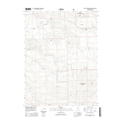
2015 Map of Hatchet Mountain Pass
USGS Topo · Published 2015About this map
Lassen National Forest dominates this section of Shasta County, where the Cascades terrain is defined by high peaks and strategic travel corridors. The primary passage through this area is Hatchet Mountain Pass, a notable divide that separates the headwaters of several critical creek systems. Level ground is scarce among the high elevations, making names like Fuller Flat and Carberry Flat significant for local history and land use patterns.
Find a feature on this map
42 named features on this map. Tap any name to fly to it.
Don’t see what you’re looking for? This feature index may not catch every label — zoom into the map to look around manually.
Map Details
Editions of this 2015 Hatchet Mountain Pass Map
This is the sole edition of this map. No revisions or reprints were ever made.
Other maps of this area

1886 · Lassen Peak
USGS Topo · 1:250,000

1892 · Lassen Peak
USGS Topo · 1:250,000

1894 · Lassen Peak
USGS Topo · 1:250,000

1935 · Burney
USGS Topo · 1:96,000

1939 · Burney
USGS Topo · 1:125,000

1955 · Westwood
USGS Topo · 1:250,000

1956 · Manzanita Lake
USGS Topo · 1:62,500
1956 · Whitmore
USGS Topo · 1:62,500
1956 · Montgomery Creek
USGS Topo · 1:62,500

1957 · Burney
USGS Topo · 1:62,500