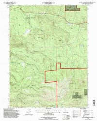
1995 Map of Hatchet Mountain Pass
USGS Topo · Published 1997About this map
Lassen National Forest dominates this mountainous portion of Shasta County, where a complex network of timber and access roads crisscrosses the high terrain. The map documents the remnants of former industrial infrastructure, most notably the Old Grade RR winding through the center of the sheet. This vanished rail line hints at the historical logging operations that once defined the economy of these slopes.
Find a feature on this map
41 named features on this map. Tap any name to fly to it.
Don’t see what you’re looking for? This feature index may not catch every label — zoom into the map to look around manually.
Map Details
Editions of this 1995 Hatchet Mountain Pass Map
This is the sole edition of this map. No revisions or reprints were ever made.
Other maps of this area

1886 · Lassen Peak
USGS Topo · 1:250,000

1892 · Lassen Peak
USGS Topo · 1:250,000

1894 · Lassen Peak
USGS Topo · 1:250,000

1935 · Burney
USGS Topo · 1:96,000

1939 · Burney
USGS Topo · 1:125,000

1955 · Westwood
USGS Topo · 1:250,000

1956 · Manzanita Lake
USGS Topo · 1:62,500
1956 · Whitmore
USGS Topo · 1:62,500
1956 · Montgomery Creek
USGS Topo · 1:62,500

1957 · Burney
USGS Topo · 1:62,500