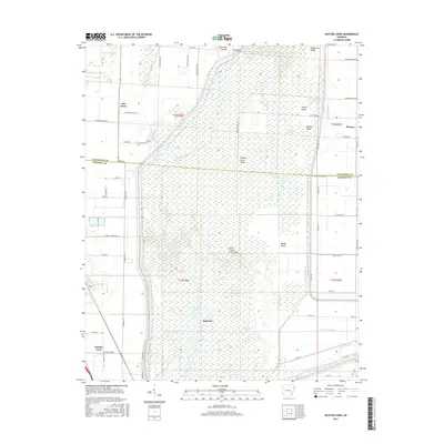
2017 Map of Hatchie Coon
USGS Topo · Published 2017About this map
The Saint Francis Sunk Lands dominate this portion of Poinsett and Craighead Counties, where the Saint Francis River fragments into a complex network of wetlands and seasonal watercourses. This unique bottomland environment is punctuated by elevated "islands" such as Hatchie Coon Island, Turkey Island, and Middle Island, which provided habitable ground amidst the inundation. The settlement at Hatchie Coon sits at the southwestern edge of this swampy reach, while Elm Grove and Donnick represent small agricultural outposts on the higher margins. Extensive drainage efforts are visible through the engineered channels of Ditch Number 1, Ditch Number 2, and Ditch Number 59, illustrating the persistent 20th-century labor to reclaim the fertile Mississippi Alluvial Plain for cultivation.
Find a feature on this map
67 named features on this map. Tap any name to fly to it.
Don’t see what you’re looking for? This feature index may not catch every label — zoom into the map to look around manually.
Map Details
Editions of this 2017 Hatchie Coon Map
This is the sole edition of this map. No revisions or reprints were ever made.
Other maps of this area

1939 · Jonesboro
USGS Topo · 1:62,500

1940 · Dee
USGS Topo · 1:62,500

1941 · Leachville
USGS Topo · 1:62,500

1941 · Marked Tree
USGS Topo · 1:62,500

1953 · Memphis
USGS Topo · 1:250,000

1956 · Leachville
USGS Topo · 1:62,500

1956 · Marked Tree
USGS Topo · 1:62,500

1956 · Memphis
USGS Topo · 1:250,000

1958 · Dee
USGS Topo · 1:62,500

1958 · Jonesboro
USGS Topo · 1:62,500