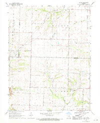
1969 Map of Hatton
USGS Topo · Published 1971About this map
The settlement of Hatton and the crossroads of Youngers anchor this late-1960s landscape at the junction of Callaway, Boone, and Audrain counties. The map reflects a rural community structured around local institutions, including Hickory Grove Ch and Pleasant Grove Ch, alongside the Westminster Cem and Youngers Cem. A distinct transition in land use is visible between the agricultural fields and the industrial extraction sites in the southwest, where Strip Mines indicate the region's active coal or clay mining history.
Find a feature on this map
27 named features on this map. Tap any name to fly to it.
Don’t see what you’re looking for? This feature index may not catch every label — zoom into the map to look around manually.
Map Details
Editions of this 1969 Hatton Map
This is the sole edition of this map. No revisions or reprints were ever made.
Other maps of this area

1886 · Jefferson City
USGS Topo · 1:125,000

1890 · Mexico
USGS Topo · 1:125,000

1890 · Moberly
USGS Topo · 1:125,000

1890 · Fulton
USGS Topo · 1:125,000

1894 · Jefferson City
USGS Topo · 1:125,000

1928 · Fulton
USGS Topo · 1:62,500

1931 · Fulton
USGS Topo · 1:62,500

1932 · Mexico
USGS Topo · 1:62,500

1944 · Millersburg
USGS Topo · 1:62,500

1945 · Centralia
USGS Topo · 1:62,500