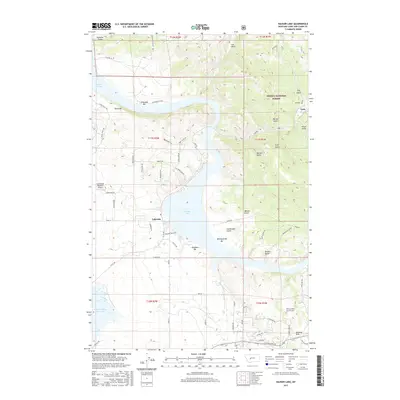
2017 Map of Hauser Lake
USGS Topo · Published 2017About this map
Hauser Lake dominates this Montana landscape, winding through a complex system of bars and gulches within the Helena National Forest. The settlement patterns here are defined by the water, with the community of Lakeside established along the southern shores and the historic mountain village of York situated to the northeast. Between these hubs, the terrain is deeply etched by features like Eldorado Bar, Danas Bar, and Metropolitan Bar, reflecting the area's geological and likely prospecting history. Infrastructure in this region serves both the local population and broader irrigation needs, evidenced by the Lonewood Meadows Airport and the Helena Valley Canal Tunnel, which passes through the Spokane Hills. Local history is anchored at the York Cemetery, while the southern reaches of the map show the industrial scale of the Helena Valley Reservoir and its connection to the surrounding watershed via Spokane Creek.
Find a feature on this map
71 named features on this map. Tap any name to fly to it.
Don’t see what you’re looking for? This feature index may not catch every label — zoom into the map to look around manually.
Map Details
Editions of this 2017 Hauser Lake Map
This is the sole edition of this map. No revisions or reprints were ever made.
Other maps of this area

1886 · Fort Logan
USGS Topo · 1:250,000

1899 · Helena
USGS Topo · 1:62,500

1948 · White Sulphur Springs
USGS Topo · 1:250,000

1950 · Canyon Ferry
USGS Topo · 1:62,500

1950 · East Helena
USGS Topo · 1:62,500

1958 · White Sulphur Springs
USGS Topo · 1:250,000

1961 · White Sulphur Springs
USGS Topo · 1:250,000
1962 · Upper Holter Lake
USGS Topo · 1:24,000

1962 · Hogback Mountain
USGS Topo · 1:24,000
1962 · Nelson
USGS Topo · 1:24,000