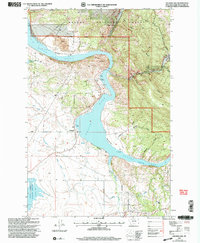
2001 Map of Hauser Lake
USGS Topo · Published 2004About this map
Hauser Lake dominates this landscape, created by the damming of the Missouri River north of the Helena Valley Regulating Reservoir. This 2001 revision, based on earlier surveys and imagery, shows a region defined by hydraulic engineering and mineral extraction. The industrial character of the land is evident in features like the Eldorado Strip Mine and numerous prospects scattered through the gulches east of the water.
Find a feature on this map
30 named features on this map. Tap any name to fly to it.
Don’t see what you’re looking for? This feature index may not catch every label — zoom into the map to look around manually.
Map Details
Editions of this 2001 Hauser Lake Map
This is the sole edition of this map. No revisions or reprints were ever made.
Other maps of this area

1886 · Fort Logan
USGS Topo · 1:250,000

1899 · Helena
USGS Topo · 1:62,500

1948 · White Sulphur Springs
USGS Topo · 1:250,000

1950 · Canyon Ferry
USGS Topo · 1:62,500

1950 · East Helena
USGS Topo · 1:62,500

1958 · White Sulphur Springs
USGS Topo · 1:250,000

1961 · White Sulphur Springs
USGS Topo · 1:250,000
1962 · Upper Holter Lake
USGS Topo · 1:24,000

1962 · Hogback Mountain
USGS Topo · 1:24,000
1962 · Nelson
USGS Topo · 1:24,000