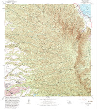
1983 Map of Hauula
USGS Topo · Published 1983About this map
Hauula and the coastal corridor along the Pacific Ocean provide a glimpse into windward Oahu during the early 1980s. The landscape is defined by the sharp transition from the coastal settlement at Hauula Beach Park to the deeply eroded ridges of the Koolau Range. Inland, the map reveals a complex network of forest reserves, including the Hauula and Kaipapau Forest Reserves, which protect the headwaters of numerous gulches and streams like Kaluanui Stream. On the leeward side of the mountains, the urbanized center of Wahiawa is visible, featuring the Wahiawa Homesteads and significant educational institutions such as Leilehua High Sch. The map also details the extensive Schofield Barracks Military Reservation and the US Naval Reservation, illustrating the long-standing military footprint in the central plateau near Whitmore Village.
Find a feature on this map
64 named features on this map. Tap any name to fly to it.
Don’t see what you’re looking for? This feature index may not catch every label — zoom into the map to look around manually.
Map Details
Editions of this 1983 Hauula Map
2 editions found
Other maps of this area

1952 · Waimea
USGS Topo · 1:24,000

1953 · Haleiwa
USGS Topo · 1:24,000

1953 · Schofield Barracks
USGS Topo · 1:24,000

1953 · Hauula
USGS Topo · 1:24,000

1954 · Oahu
USGS Topo · 1:250,000

1954 · Kahuku
USGS Topo · 1:24,000

1954 · Kahana
USGS Topo · 1:24,000

1954 · Kaneohe
USGS Topo · 1:24,000

1954 · Waipahu
USGS Topo · 1:24,000

1959 · Kaneohe
USGS Topo · 1:24,000