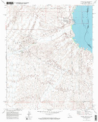
1970 Map of Havasu Lake
USGS Topo · Published 1982About this map
Chemehuevi Indian Reservation lands dominate this 1970 desert landscape along the Colorado River at the California-Arizona border. The settlement of Havasu Lake serves as a focal point for recreation and local life, featuring a Marina, Picnic Area, and a Trailer Park. The topography is defined by the broad Chemehuevi Valley and the drainage of Chemehuevi Wash, which cuts through the arid terrain toward the reservoir. Beyond the immediate shoreline, the map reveals the region's resource-driven history through several prospects and a mine, while the Havasu Lake Road and various Jeep Trails provide the only access into the backcountry. The map also records an indefinite boundary for the reservation, reflecting the ongoing complexities of land management and tribal sovereignty in the late twentieth century.
Find a feature on this map
19 named features on this map. Tap any name to fly to it.
Don’t see what you’re looking for? This feature index may not catch every label — zoom into the map to look around manually.
Map Details
Editions of this 1970 Havasu Lake Map
3 editions found
Other maps of this area

1903 · Needles
USGS Topo · 1:125,000

1904 · Needles Special
USGS Topo · 1:125,000

1911 · Parker
USGS Topo · 1:125,000

1943 · Topock
USGS Topo · 1:62,500

1943 · Whipple Mts.
USGS Topo · 1:62,500

1950 · Topock
USGS Topo · 1:62,500

1950 · Sawtooth Range
USGS Topo · 1:62,500

1950 · Whipple Mts
USGS Topo · 1:62,500

1950 · Savahia Peak
USGS Topo · 1:62,500

1951 · Topock
USGS Topo · 1:62,500