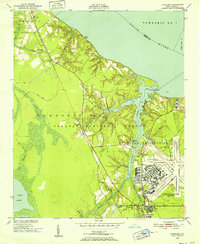
1949 Map of Havelock
USGS Topo · Published 1966About this map
The U S Marine Corps Air Station Cherry Point dominates the eastern landscape of this 1949 survey, showcasing the massive military installation shortly after its establishment during World War II. The base is situated along the banks of Slocum Creek and Hunters Branch, where its runways and infrastructure sit adjacent to the dense woodlands of the Croatan National Forest. This era shows the expansion of military aviation infrastructure into the coastal wetlands and pine forests of North Carolina, effectively reshaping the local economy around Havelock.
Find a feature on this map
50 named features on this map. Tap any name to fly to it.
Don’t see what you’re looking for? This feature index may not catch every label — zoom into the map to look around manually.
Map Details
Editions of this 1949 Havelock Map
4 editions found
Other maps of this area

1901 · New Bern
USGS Topo · 1:62,500

1903 · New Bern
USGS Topo · 1:62,500

1942 · Maysville
USGS Topo · 1:62,500

1948 · Maysville
USGS Topo · 1:62,500

1949 · Havelock
USGS Topo · 1:24,000

1949 · Newport
USGS Topo · 1:24,000

1949 · Cherry Point
USGS Topo · 1:24,000

1949 · Masontown
USGS Topo · 1:24,000

1950 · New Bern
USGS Topo · 1:24,000

1950 · Upper Broad Creek
USGS Topo · 1:24,000