
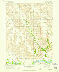
1958 Map of Havens
USGS Topo · Published 1959About this map
Clarksville and the surrounding Platte River valley townships are meticulously documented in this late 1950s survey. The landscape is defined by the winding paths of Prairie Creek and Silver Creek, which bisect the agricultural sections. A significant historical marker, the Old Indian Boundary, cuts across the center of the sheet, providing a spatial record of 19th-century land divisions between Nance and Merrick Counties. Rural education and transport are anchored by sites such as Hilltop Sch and Midway Sch, while the Union Pacific railroad line runs through the small settlement at Havens. This map serves as a detailed record of the mid-century agrarian layout before modern consolidation altered many of these local landmarks.
Find a feature on this map
9 named features on this map. Tap any name to fly to it.
Don’t see what you’re looking for? This feature index may not catch every label — zoom into the map to look around manually.
Map Details
Editions of this 1958 Havens Map
This is the sole edition of this map. No revisions or reprints were ever made.
Other maps of this area

1896 · Stromsburg
USGS Topo · 1:125,000

1955 · Fremont
USGS Topo · 1:250,000

1957 · Fremont
USGS Topo · 1:250,000

1958 · Fremont
USGS Topo · 1:250,000

1958 · Genoa
USGS Topo · 1:24,000
1958 · Merchiston
USGS Topo · 1:24,000

1958 · Fullerton
USGS Topo · 1:24,000

1958 · Fullerton NE
USGS Topo · 1:24,000

1958 · Silver Creek
USGS Topo · 1:24,000
1962 · Swedehome
USGS Topo · 1:24,000