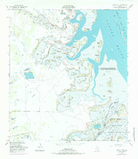
1952 Map of Hawk Island
USGS Topo · Published 1984About this map
The Laguna Madre defines this coastal landscape at the junction of Willacy and Cameron counties, where the tidal flats and marshy islands create a complex interface between land and sea. This 1952 survey, photorevised in 1970, captures the transitional environment of the Laguna Atascosa National Wildlife Refuge before extensive modern development. The map reveals a remote ranching and maritime landscape, marked by numerous named wells such as La Oveja Well and Guilotal Well that reflect the essential search for freshwater in this saline environment. The Arroyo Colorado winds through the lower portion of the sheet, while the Intracoastal Waterway cuts through the Spoil Banks, showing the early 20th-century infrastructure that opened this stretch of the Texas coast to commercial navigation. Names like Chubby Island and Goose Hill highlight the local nomenclature of the South Texas brush country and its barrier islands.
Find a feature on this map
23 named features on this map. Tap any name to fly to it.
Don’t see what you’re looking for? This feature index may not catch every label — zoom into the map to look around manually.
Map Details
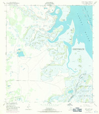
Editions of this 1952 Hawk Island Map
3 editions found
Other maps of this area

1921 · Tarida Ranch
USGS Topo · 1:62,500

1929 · Buena Vista
USGS Topo · 1:24,000

1930 · La Leona
USGS Topo · 1:24,000

1933 · Paso Real
USGS Topo · 1:31,680

1935 · Buena Vista
USGS Topo · 1:31,680

1936 · La Leona
USGS Topo · 1:31,680

1952 · Green Island
USGS Topo · 1:24,000

1952 · South of Potrero Lopeno SE
USGS Topo · 1:24,000

1952 · Hawk Island
USGS Topo · 1:24,000

1952 · Port Mansfield
USGS Topo · 1:24,000