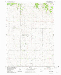
1981 Map of Hawkeye
USGS Topo · Published 1982About this map
The town of Hawkeye serves as the central hub of this northeast Iowa landscape, situated at the junction of several rural townships including Bethel and Windsor. The map reveals a highly structured agricultural grid, where fine red lines delineate field boundaries and drainage is managed through the winding courses of Crane Creek and the North Branch Volga River. Local history is deeply embedded in the land, seen through numerous family and community burial grounds such as Oak Lawn Cem and South Windsor Cem.
Find a feature on this map
26 named features on this map. Tap any name to fly to it.
Don’t see what you’re looking for? This feature index may not catch every label — zoom into the map to look around manually.
Map Details
Editions of this 1981 Hawkeye Map
This is the sole edition of this map. No revisions or reprints were ever made.
Other maps of this area

1901 · Oelwein
USGS Topo · 1:125,000

1906 · Decorah
USGS Topo · 1:125,000

1954 · Mason City
USGS Topo · 1:250,000

1954 · Waterloo
USGS Topo · 1:250,000

1955 · Waterloo
USGS Topo · 1:250,000

1957 · Mason City
USGS Topo · 1:250,000

1958 · Mason City
USGS Topo · 1:250,000

1958 · La Crosse
USGS Topo · 1:250,000

1959 · Dubuque
USGS Topo · 1:250,000

1961 · Dubuque
USGS Topo · 1:250,000