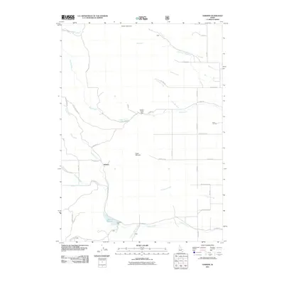
2011 Map of Hawkins
USGS Topo · Published 2011About this map
Hawkins sits as a central junction point in this high-altitude drainage basin of Bannock County, where mountain peaks like Old Tom Mountain and Cedar Mountain frame a landscape defined by water management and ranching roads. The area's hydrology is complex, featuring the Hawkins Reservoir and the engineered Hawkins Dam, which regulate the flow of Hawkins Creek and its tributaries. To the northwest, the Wycross Ditch indicates the historical importance of irrigation in this arid environment, while the narrow Garden Creek Gap serves as a natural corridor for Garden Creek. The map provides a detailed view of the local road network, from established routes like W Arimo Rd to the more remote Upper Battlesnake Rd. For those researching local heritage, the Robin Cemetery in the eastern hills remains a significant landmark of early community settlement, while place names like Deadwood Creek and Yellow Dog Creek hint at the rugged character of the original pioneers who named these drainage forks.
Find a feature on this map
46 named features on this map. Tap any name to fly to it.
Don’t see what you’re looking for? This feature index may not catch every label — zoom into the map to look around manually.
Map Details
Editions of this 2011 Hawkins Map
This is the sole edition of this map. No revisions or reprints were ever made.
Other maps of this area

1954 · Pocatello
USGS Topo · 1:250,000

1958 · Pocatello
USGS Topo · 1:250,000

1968 · Dairy Creek
USGS Topo · 1:24,000

1968 · Downey West
USGS Topo · 1:24,000

1968 · Wakley Peak
USGS Topo · 1:24,000

1968 · Hawkins
USGS Topo · 1:24,000

1968 · Clifton Creek
USGS Topo · 1:24,000
1968 · Arimo
USGS Topo · 1:24,000

1968 · Bradley Mtn
USGS Topo · 1:24,000

1968 · Mc Cammon
USGS Topo · 1:24,000