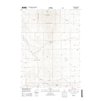
2013 Map of Hawkins
USGS Topo · Published 2013About this map
Hawkins sits as a primary point of reference in this landscape of southern Idaho, where the mountainous terrain of Old Tom Mtn and Cedar Mtn gives way to the open Marsh Valley in the east. The drainage network is complex, characterized by numerous creeks such as Garden Cr, Birch Cr, and Deadwood Cr flowing through the southern reaches of the Caribou National Forest. Water management for agriculture is evident through the Wycross Ditch and the containment of the Hawkins Reservoir. This 2013 survey highlights the intersection of the natural landscape at Garden Creek Gap with a rural road network that connects isolated features like the Robin Cem, providing a detailed view of the modern land use and topography in this corner of Bannock County.
Find a feature on this map
60 named features on this map. Tap any name to fly to it.
Don’t see what you’re looking for? This feature index may not catch every label — zoom into the map to look around manually.
Map Details
Editions of this 2013 Hawkins Map
This is the sole edition of this map. No revisions or reprints were ever made.
Other maps of this area

1954 · Pocatello
USGS Topo · 1:250,000

1958 · Pocatello
USGS Topo · 1:250,000

1968 · Dairy Creek
USGS Topo · 1:24,000

1968 · Downey West
USGS Topo · 1:24,000

1968 · Wakley Peak
USGS Topo · 1:24,000

1968 · Hawkins
USGS Topo · 1:24,000

1968 · Clifton Creek
USGS Topo · 1:24,000
1968 · Arimo
USGS Topo · 1:24,000

1968 · Bradley Mtn
USGS Topo · 1:24,000

1968 · Mc Cammon
USGS Topo · 1:24,000