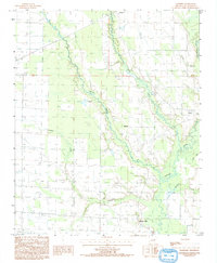
1992 Map of Hawkins
USGS Topo · Published 1993About this map
The L'Anguille River meanders through this portion of St. Francis County, defining a landscape of agricultural water management and small rural hubs in the early 1990s. The settlement at Hawkins sits central to a web of waterways, including First Creek, Second Creek, and Cypress Creek, which drain the surrounding lowlands. A notable industrial landmark, Slonikers Mill, is situated near the southern boundary, reflecting the area's local processing history.
Find a feature on this map
16 named features on this map. Tap any name to fly to it.
Don’t see what you’re looking for? This feature index may not catch every label — zoom into the map to look around manually.
Map Details
Editions of this 1992 Hawkins Map
This is the sole edition of this map. No revisions or reprints were ever made.
Other maps of this area

1939 · Wynne
USGS Topo · 1:62,500

1939 · Hunter
USGS Topo · 1:62,500

1940 · Brinkley
USGS Topo · 1:62,500

1940 · Marianna
USGS Topo · 1:62,500

1948 · Helena
USGS Topo · 1:250,000

1950 · Helena
USGS Topo · 1:250,000

1953 · Memphis
USGS Topo · 1:250,000

1955 · Helena
USGS Topo · 1:250,000

1956 · Memphis
USGS Topo · 1:250,000

1956 · Hunter
USGS Topo · 1:62,500