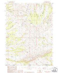
1987 Map of Hawks Nest
USGS Topo · Published 1987About this map
Richards Mountain and the high plateaus of the Wyoming-Utah border define this landscape as it appeared in the late 1980s. The terrain is characterized by a complex network of drainages including the West Fork Currant Creek, Middle Fork Currant Creek, and East Fork Currant Creek, which flow north from the high ridges of the Daggett and Sweetwater county line. The naming of numerous water sources, such as Lousy George Spring, Bates Spring, and Angelovie Spring, highlights the importance of discrete water points in this arid environment.
Find a feature on this map
37 named features on this map. Tap any name to fly to it.
Don’t see what you’re looking for? This feature index may not catch every label — zoom into the map to look around manually.
Map Details
Editions of this 1987 Hawks Nest Map
This is the sole edition of this map. No revisions or reprints were ever made.
Other maps of this area

1885 · Ashley
USGS Topo · 1:250,000

1952 · Clay Basin
USGS Topo · 1:24,000

1952 · Dutch John Mtn
USGS Topo · 1:24,000

1952 · Goslin Mtn
USGS Topo · 1:24,000

1954 · Vernal
USGS Topo · 1:250,000

1954 · Rock Springs
USGS Topo · 1:250,000

1957 · Currant Creek Ranch
USGS Topo · 1:62,500

1958 · Vernal
USGS Topo · 1:250,000

1958 · Rock Springs
USGS Topo · 1:250,000

1960 · Vernal
USGS Topo · 1:250,000