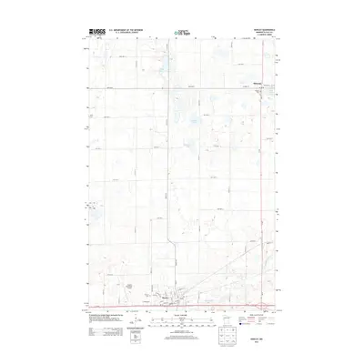
2013 Map of Hawley
USGS Topo · Published 2013About this map
Hawley and Hitterdal serve as the primary hubs in this section of Clay County, connected by a network of rural roads and the Buffalo River. This 2013 survey illustrates the local agricultural landscape, where numerous small water bodies like Anderson Lake, Solwald Lake, and Tattey Lake are scattered across the terrain. The presence of several burial grounds, including Hawley Cem, W Salem Cem, and Lysne Cem, provides significant points of interest for those researching local family histories. The infrastructure of the area is well-defined by the corridor of Us-10 passing through the southern portion of the sheet near Hawley Municipal Airport, while MN-32 provides a vertical north-south link through Hitterdal. These transit routes, combined with a precise grid of numerical avenue labels, show the organized development of this Minnesota prairie region.
Find a feature on this map
36 named features on this map. Tap any name to fly to it.
Don’t see what you’re looking for? This feature index may not catch every label — zoom into the map to look around manually.
Map Details
Editions of this 2013 Hawley Map
This is the sole edition of this map. No revisions or reprints were ever made.
Other maps of this area

1918 · Flom
USGS Topo · 1:62,500

1918 · Ulen
USGS Topo · 1:62,500

1919 · Hawley
USGS Topo · 1:62,500

1952 · Grand Forks
USGS Topo · 1:250,000

1953 · Fargo
USGS Topo · 1:250,000

1956 · Fargo
USGS Topo · 1:250,000

1956 · Grand Forks
USGS Topo · 1:250,000

1966 · Grand Forks
USGS Topo · 1:250,000
1966 · Tilde Lake
USGS Topo · 1:24,000
1966 · Ulen
USGS Topo · 1:24,000