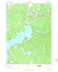
1966 Map of Hawley
USGS Topo · Published 1967About this map
The vast expanse of Lake Wallenpaupack dominates this 1960s landscape, where the Wayne and Pike county line runs through the water. This massive reservoir, with its complex shoreline including Spinnler Pt, transformed the region's geography, though older settlements like Hawley and Wilsonville remain established at the lake's northern edge. The industrial and transport history of the area is evident through the Erie-Lackawanna railroad line following the path of the Lackawaxen River.
Find a feature on this map
56 named features on this map. Tap any name to fly to it.
Don’t see what you’re looking for? This feature index may not catch every label — zoom into the map to look around manually.
Map Details
Editions of this 1966 Hawley Map
3 editions found
Other maps of this area

1892 · Honesdale
USGS Topo · 1:62,500

1920 · Damascus
USGS Topo · 1:62,500

1923 · Damascus
USGS Topo · 1:62,500

1928 · Ariel
USGS Topo · 1:62,500

1932 · Ariel
USGS Topo · 1:62,500

1935 · Hawley
USGS Topo · 1:62,500

1938 · Hawley
USGS Topo · 1:62,500

1943 · Honesdale
USGS Topo · 1:125,000

1944 · Damascus
USGS Topo · 1:62,500

1946 · Honesdale
USGS Topo · 1:24,000